Welcome to our website and cycling club. Club membership is open to all! Whether you're a racer, recreation rider, or just starting out, the Sierra Foothills Cycling Club wants you! Get to know more about our club in our FAQ, or drop us a line from our contacts list.
Our Mission
Our club's mission is to share our passion for bicycle riding through organized events, including a variety of weekly rides designed for both novice and experienced bicyclists of all ages.
Our Rides
Our group bike rides traverse the beautiful foothills of the Sierras in and around the city of Auburn. For more information about our rides visit: ride info. Join us to explore the area while having fun, getting fit, and meeting fellow cyclists.
Ride Description and Notes: Beat the heat with this short (finish early) casually paced ride around Meadow Vista. I'll have route sheets and I'll sweep - no rider left behind. Socializing at The Local Cafe after the ride.
Route Cue Sheet --------------------------------------------- Vista Thursday #1 Applegate revised -- 16.3 miles 0.1 Left -- Meadow Vista Road 1.9 U-turn at McElroy Rd 3.7 Right -- Placer Hills Road 5.2 Right -- Pinewood Way 5.9 Left -- Lake Arthur Road 6.1 Right -- Placer Hills Road 6.3 Left -- Applegate Road 8.9 Left -- Crother Road 9.3 Right -- Crother Road 10.5 Left -- Placer Hills Road 11.9 Right -- Combie Road 12.3 Left -- Volley Road 13.4 Right -- Volley Circle 14.0 Right -- Volley Road 15.0 Right -- Combie Road 15.5 Right -- Placer Hills Road 16.0 Right -- Meadow Vista Road 16.1 Left into MV Park Leader Cell:
Ride Description and Notes: Friday is going to be hot so let's get out and get it done! Join me for a 25 miler from the Loomis Train Depot. It's a pretty flat ride so we can beat the heat. Slather on the sunscreen, fill up your bottles, and come ready to ride. No sweep, but I'll be towards the back. Please print or download a route sheet. Coffee across the street at Pause after the ride.
Route Cue Sheet --------------------------------------------- Loomis Train Depot 4 24 -- 25.3 miles 0.1 Left -- Horseshoe Bar Road 0.1 Left -- Taylor Road 0.2 Right -- Webb Street 0.2 Left -- Laird Street 0.4 Right -- Thornwood Drive 0.5 Left -- Sun Knoll Drive 0.6 Right -- King Road 1.9 Right -- Val Verde Road 4.7 Keep Right -- Val Verde Road 4.7 Right -- Val Verde Road 4.7 Make a U-turn -- Val Verde Road 6.2 Left -- Barton Road 6.3 Left -- Barton Road 7.6 Right -- Cavitt Stallman Road 10.0 Left -- Olive Ranch Road 11.0 Right -- Stirling Street 11.1 Left 11.1 Right -- Stirling Street 11.2 Right -- Olive Ranch Road 11.9 Left -- Barton Road 12.8 Right -- Del Oro Road 13.3 Left -- Del Oro Road 13.4 Right -- Cavitt Stallman Road 14.5 Left -- Auburn Folsom Road 19.5 Left -- King Road 21.8 Right -- Penryn Road 23.2 Left -- Taylor Road 25.2 Right -- Webb Street 25.2 Left Leader Cell:
Saturday - Penryn Park & Ride 8 SFCC Sat, Aug 1, 8:00am 0 comments
Ride Description and Notes: Saturday looks like it is going to be warm weather for a ride! Come out early for a easy ride on familiar roads with friends new and old. We'll cover Powerhouse, Rattlesnake, Auburn Folsom, Dick Cook, Barton, etc. Short and quick regroups at Shirland and Rattlesnake and at Brace and Sierra College. I will sweep the ride.
Coffee and conversation at Roanie's after the ride.
Be sure to be aware of speed bumps!! Call them out when you see them.
Route Cue Sheet --------------------------------------------- Penryn Park & Ride 8 SFCC -- 25.2 miles 0.1 Right -- Penryn Road 0.3 Left -- Boulder Creek Road 0.3 Right -- Boulder Creek Road 1.3 Right -- Aspen Drive 2.6 Left -- Brennans Road 3.8 Left -- Newcastle Road 4.6 Right -- Powerhouse Road 5.1 Keep Right -- Powerhouse Road 5.4 Keep Left -- Powerhouse Road 5.4 Keep Right -- Powerhouse Road 6.4 Left -- Auburn Folsom Road 6.8 Right -- Shirland Tract Road 6.8 Right -- Rattlesnake Road 8.3 Right -- Newcastle Road 9.4 Left -- Auburn Folsom Road 13.0 Right -- Dick Cook Road 14.6 Left -- Val Verde Road 16.8 Right -- Barton Road 18.8 Left -- Brace Road 19.9 Right -- Sierra College Boulevard 20.1 Right -- Sierra College Boulevard 21.2 Right -- King Road 22.6 Left -- Taylor Road 24.5 Right -- Penryn Road 25.1 Right -- Boyington Road Leader Cell:
Saturday - MINER'S RAVINE / LINDA CREEK LOOP-2: 17.3 miles, 612' climbing. Sat, Aug 1, 8:00am 0 comments
Where: Granite Bay Community Park Douglas Blvd, Granite Bay (map)
Leader Name: Jennifer Fink E-mail: jenniferfink6@icloud.com
Ride Description and Notes: Miner's Ravine is now a full loop trail with lots of shade, perfect for the upcoming hot week!
All EZ Rider routes are no drop, extra social and loads of fun. We can opt for a mid-ride exit into Old Town Roseville for some extra miles, or a snack break if the group decides that's what they want.
Route Cue Sheet --------------------------------------------- MINER'S RAVINE / LINDA CREEK LOOP-2: 17.3 miles, 612' climbing. -- 17.3 miles
0.0 Right (north) -- Barton Road 0.3 Left -- Macargo Road 0.8 Right -- Berg Street 1.2 Left -- Olive Ranch Road 2.6 Cross Cavitt Stallman and continue west on paved bike path to your Left. 2.6 Right and follow road thru church parking lot, to stop light. 2.7 Cross Sierra College Blvd. 2.8 Right -- sidewalk and ride sidewalk (against traffic) to Miner's Ravine Trail. 2.9 Left -- Miner's Ravine Trail. 4.3 Keep Right -- Miners Ravine Trail 6.2 Keep Right -- Miner's Ravine Trail 6.3 Keep Right -- Miner's Ravine Trail 7.4 Right -- sidewalk instead of crossing bridge over creek. Left to parallel Oak Street on sidewalk until you get past traffic circle. 7.8 Left -- Bulen Street NOTE: Shady Coffee on Right side of street at mile 7.8. 7.9 Left on Douglas Blvd. Use crosswalk at Left , if necessary. 7.9 Right -- Irene Avenue 8.1 Right -- Cherry Avenue 8.3 Left -- Clinton Avenue 8.6 Use sidewalk toLeft -- bike trail - descends under street. 8.7 Left. 8.7 Vernon Street trailhead 10.9 Right to stay on main trail. 11.1 Right, then follow sign to Maidu Park. 11.3 Right -- Meadowlark Way 11.6 Cross Rocky Ridge, then enter Maidu Park. Left & ride through parking lot. 11.8 Right, -- bike trail. 12.0 Right at sign for McLaren Drive. 12.1 Left on bike trail along McLaren Drive. 12.6 Left on bike trail. 12.9 Right -- Parkhill Drive. 13.2 Right -- East Roseville Parkway. 13.8 Cross Sierra College Blvd. 16.2 Left on Barton Road. 17.3 Right into Granite Bay Community Park. DONE! Leader Cell:
Sunday - EZ-Ride Loomis to Granite Bay, 26 Miles. Sun, Aug 2, 7:30am 0 comments
Where: 4570 Lake Forest Dr, Loomis, CA 95650 (map)
Ride Description and Notes: Earlier Start Time, 7:30 am.
Come out and join me for a pleasurable ride from Loomis to Granite Bay. This is a No Drop Ride and Pace my pace will be kept 12-14 mph. Restroom at Start Location and 14 miles into Route at Granite Bay Community Park.
Take Note of High Temps. Please bring plenty of water and snacks to sustain hydration and energy.
Meeting Location
7:15 am @ Sterling Pointe Park
4570 Lake Forest Dr., Loomis, CA 95650
7:30 am, Roll out.
If this is you're first ride, please come a few minutes earlier to sign waiver.
Route Cue Sheet --------------------------------------------- EZ-Ride Loomis to Granite Bay, 26 Miles. -- 26.0 miles 0.0 Left -- Rim Rock Cir 0.6 Right -- Lake Forest Dr 1.0 Cont -- Lomida Ln 1.7 Left -- Auburn Folsom Rd 3.3 Right to stay on Auburn Folsom Rd 4.9 Right -- Cavitt Stallman Rd 9.5 Left -- Douglas Blvd 9.8 Right toward Woodgrove Way 9.8 Right -- Woodgrove Way 10.2 Left -- Greyhawk Dr 10.4 Left -- Eureka Rd 10.7 Cont -- Wellington Way 11.1 Left -- E Roseville Pkwy 12.9 Left -- Barton Road 13.9 Right 14.1 Make a U-turn 14.2 Left -- Barton Rd 14.7 Left -- Eureka Rd 15.7 Left -- Auburn Folsom Rd 15.9 Right -- Fuller Dr 16.3 Right -- Bronson Dr 16.5 Left -- Hill Rd 16.8 Right -- Mooney Rd 16.8 Left -- Hill Rd 17.1 Left -- Douglas Blvd 17.3 Right toward Douglas Blvd 17.3 Left -- Douglas Blvd 18.0 Right 18.1 Left 18.1 Right -- Auburn Folsom Road 18.1 Right -- Auburn Folsom Road 18.8 Right -- Morningside Drive 20.6 Right -- Twin Rocks Road 21.8 Left -- Walden Woods Way 21.8 Left -- Walden Woods Way 22.3 Right -- Vireo Way 22.5 Keep Left -- Ardea Way 22.6 Right -- Auburn Folsom Road 24.8 Right -- Lo Mida Lane 25.9 Right Leader Cell:
Sunday - Stumpy to Loon & Back Sun, Aug 2, 9:00am 0 comments
Ride Description and Notes: Out and back to Loon Lake (boat ramp). Our rest stop (bathroom/water) will be at boat ramp.
Route Cue Sheet --------------------------------------------- Stumpy to Loon & Back -- 40.8 miles 0.0 Elevation 4275 11.0 Top 6100 14.2 Left -- Ice House Rd 15.4 Right US Frst Service Rd 3 19.5 Top 6500 19.8 Right towards boatramp/dump/campground 20.3 Head towards boat ramp, picnic table under tree 20.9 Left -- Ice House Road 25.3 Left -- Ice House Rd 26.6 Right -- Wentworth Springs Rd 29.7 Top 6100 40.7 Done Elevation 4275 Leader Cell:
Tuesday - Newcastle to Auburn Loop 27.4 miles/2150 climb Tue, Aug 4, 8:00am 0 comments
Where: Newcastle Park and Ride Newcastle, CA (map)
Leader Name: Larry Merlo E-mail: larry_merlo@yahoo.com
Ride Description and Notes: It will be another hot one Tuesday morning so this route gets the climbing over early. We'll head up Indian Hill and thru Auburn to Dry Creek where we will regroup at the Regional Park at mile 15. The return to Newcastle includes Joeger, Millertown, and Wise.
Coffee at North Fork Chai Co. afterwards.
Route Cue Sheet --------------------------------------------- Newcastle to Auburn Loop 27.4 miles/2150 climb -- 27.4 miles 0.1 Right -- Indian Hill Rd 2.4 Left -- Auburn Folsom Rd 4.1 Right -- High St 4.7 Right -- Lincoln Way 5.1 Right -- El Dorado Street 5.1 At roundabout, take exit 3 -- Lincoln Way 5.2 Right -- Aeolia Drive 6.0 Right -- Foresthill Avenue 6.6 Left -- Russell Road 7.2 Right -- Lincoln Way 8.4 Left -- Bowman Undercrossing Road 8.6 Right -- Bowman Road 10.6 Left -- Dry Creek Road 14.7 Left -- Richardson Dr 15.2 Regional Park REGROUP 15.2 Make a U-turn at bathrooms on the Left 15.6 Cross Dry Creek Rd to stay on Richardson 16.2 Left -- Joeger Road 18.9 Left -- Mount Vernon Road 19.5 Right -- Mount Vernon Road 21.8 Right -- Millertown Road 24.1 Left -- Wise Road 24.7 Right -- Ophir Road 26.6 Right -- Taylor Road 26.9 Left -- Old State Highway 27.2 Left -- Newcastle Road 27.4 Done Leader Cell:
Wednesday - The Most Contrived and Circuitous Route Ever Conceived from Meadow Vista. Wed, Aug 5, 8:00am 0 comments
This route meanders through the beautiful rolling hills and homes in the south west Meadow Vista Area, exploring many roads that you may have not ridden on before. The ups and downs make it a dramatic route with great views. If you just want to start and return to Meadow Vista, the route is 25M and 2608 ft of elevation gain.The extra loop that goes up Meadow Gate adds another 9.3M and 936 ft of elevation gain.
There are a lot of twists and turns on this route so it’s best to pay attention. There are some notes on the map about three fire access roads, and not private property gates. Two roads are paved, the third has 50 meters of dirt/ gravel which can be ridden or walked. If you look at the RWGPS route, I included photos in the descriptions so you can see the gates.
Print your own route sheet.
Route Cue Sheet --------------------------------------------- The Most Contrived and Circuitous Route Ever Conceived from Meadow Vista. -- 34.2 miles 0.2 Right -- Meadow Vista Rd 0.3 Right -- Placer Hills Rd 1.2 Right -- Sugar Pine Rd 1.4 Right to stay on Sugar Pine Rd 2.1 Right -- East Sierra View Drive 2.6 Left -- Sugar Pine Road 2.8 Right 2.8 Fire Access Gate - Walk Around 2.8 Right -- Winchester Club Drive 2.9 Right -- Shady Tree Lane 3.5 Right -- Winchester Club Drive 3.6 Right -- Grand Knoll Drive 4.0 Left -- Ridgemore Drive 4.2 Right -- Winchester Club Drive 5.1 Left -- Long View Dr 5.7 Left -- Winchester Club Drive 7.2 Right -- Pinnacle View Drive 7.5 Right -- Granite Park Lane 7.6 Fire Access Gate - Put bike through gate 7.7 Right -- Bancroft Road 8.4 Left -- Christian Valley Road 9.4 Right -- Dry Creek Road 11.9 Right 11.9 Left -- Dry Creek Road 12.3 Right -- Blue Grass Drive 12.6 Right -- Riva Ridge Cir 13.3 Left -- Blue Grass Dr 13.4 Right -- Moss Rock Dr 13.7 Left -- Skyview Dr 14.3 Right -- Moss Rock Dr 15.3 Left -- Virginia Dr 15.4 Left -- Helen Ln 16.0 Left -- Virginia Dr 16.1 Right -- Stanley Drive 16.8 Right -- Gayle Lane 16.9 Keep Left -- Gayle Lane 17.7 Right -- Allen Drive 18.0 Left -- Gregg Way 18.3 Left -- Christian Valley Road 19.7 Left -- Mary Lane 20.5 Cont -- McElroy Rd 22.5 Left to stay on McElroy Rd 22.7 Left to stay on McElroy Rd 23.1 Right -- Meadow Vista Road 25.0 Left -- Placer Hills Rd 25.4 Right -- Meadow Gate Road 26.9 Right -- Meadow Gate Road 27.2 Left -- Lake Arthur Road 27.6 Cont -- Crother Road 28.8 Right -- Placer Hills Road 29.8 Left -- Naturewood Drive 31.0 50M of dirt road. Ride or walk. 31.2 Rough road. 31.3 Right -- Hillsdale Road 31.5 Cont -- Hillsdale Road 31.8 Left -- Combie Road 33.4 Right -- Placer Hills Road 33.9 Right -- Meadow Vista Road 34.0 Left 34.0 Keep Left 34.2 Left Leader Cell:
Thursday rides are hilly, shorter, more casually paced rides (usually around 20 miles with approximately 1800 feet of climb). Ride is swept and everyone more or less stays fairly close together. There are also numerous regroups on this ride. Currently, this ride is out of Meadow Vista Park in Meadow Vista. The last Thursday of the month starts out at Railhead Park in Auburn.
The rides usually start at Meadow Vista Park. However, check the calendar for occasional changes to the start location.
All pace ride. Riders ride at their own pace or form groups riding a similar pace. Often times, there are no regroups due to the short distances offered. Approximately 25 miles. No sweep.
The Saturday ride USUALLY meets at PENYN PARK AND RIDE.
There is an A group and a B group. The groups can spread out then you can ride your own pace...usually two or three groups with pairs scattered about and some single riders too.
The ride ranges between 25-30 mi with 1500k- 2000k ft of climbing.
Some new and old trails on this Enduro. We will start with a ride around Donner Lake,then take the Deerfield Trail to 89. We'll get on the Legacy Trail out to the Martis Valley Trail to Northstar.
This next section is modified from last year: We will take the extended Martis Trail to the Northstar Village parking lot. Note RideWithGPS does not have this trail so the map shows a straight line.
Final climbs on Rainbow and Schussing Way.
Regroups with bathrooms and water:
- Northstar Village - mile 21
- Riverview Sports Park - mile 30
- Old Greenwood golf course - mile 42
Chit Chat and goodies at Coffee Bar Bakery afterwards.
Route Cue Sheet --------------------------------------------- Truckee Trails 3 -- 52.0 miles 0.0 Left -- Donner Pass Rd 0.3 At the traffic circle, continue straight to stay on Donner Pass Rd 0.6 Left -- Donner Mem Dr/S Shore Dr 0.8 Right to stay on S Shore Dr 2.6 Left to stay on S Shore Dr 4.4 Right -- Donner Pass Rd 7.9 At the traffic circle, take the 1st exit -- Cold Stream Rd 8.0 Left into Donner State Park 9.2 Left -- Boulders Rd 9.2 Right -- Deerfield Dr 9.4 Right -- CA-89 S 9.8 Left -- W River St 11.0 Right -- Riverside Dr 11.6 Left -- Old Brockway Rd 11.6 Right -- Brockway Rd 12.9 Right -- Hope Ct 13.1 Left 13.3 Cont -- Martis Vly Trl 13.4 Left to stay on Martis Vly Trl 17.8 Left -- NEW BIKE TRAIL 18.9 Right -- N Village Dr
- REGROUP 18.9 Left -- Northstar Dr 19.1 Left -- Big Springs Dr 20.3 Cont -- Highlands View Rd 20.7 Left toward Highlands View Rd 20.7 Right -- Highlands View Rd 23.7 Left 24.1 Right 25.6 Right 25.8 Left 27.4 Cont -- Martis Vly Trl 28.3 Right -- Schaffer Mill Rd 28.3 Cont -- Truckee Airport Rd/Truckee-Tahoe Arpt Rd 28.5 Left -- Soaring Way 29.0 At the traffic circle, take the 1st exit -- Joerger Dr 29.6 Left - REGROUP at Ball Park Restrooms 29.8 Right -- Legacy Trail 33.1 Right -- Glenshire Dr 33.4 Left -- Dorchester Dr 33.6 Left -- Manchester Dr 34.1 Left -- Whitehorse Rd 34.9 Left -- Stallion Way 35.7 Left -- Whitehorse Rd 35.8 Right -- Glenshire Dr 40.6 Right -- Highland Ave 41.2 Right -- Floriston Ct 41.2 Right -- Olympic Blvd 41.4 Left -- Lookout Loop
-- REGROUP at golf course bathroom 42.0 Right -- Fairway Dr 43.2 Left -- Overland Trail 43.4 Cont -- Prosser Vlg Rd 44.5 Left 44.6 Left -- Prosser Dam Rd 44.8 Right -- Ghirard Rd 45.2 Right -- Bottcher Loop 45.5 Right -- Kelley Dr 45.8 Right -- Rainbow Dr 47.0 Left -- E Alder Creek Rd 48.5 Left -- Schussing Way 50.0 Left -- Lausanne Way 50.8 Left -- Northwoods Blvd 51.8 Right -- Donner Pass Rd 52.0 Left -- Hwy Rd Leader Cell:
Sunday rides are at least 40 miles in length, giving moderate level riders the chance to ride a little further than our average distance. You'll find some rides that are flattish and some that are killer hilly. The average pace of the Sunday rides varies hugely based on the distance and the amount of climb. The start location of this ride varies weekly, so check the calendar.
Tuesday RideTue, Aug 11, 8:00am 0 comments
Where: Newcastle Park and Ride Newcastle, CA (map)
Tuesday rides are variable, depending on who leads and who shows up. Generally, the climbing is 1500-2500 feet, and the distance is 18-25 miles. Oftentimes, there are no regroups due to the short distances offered. This ride's start location is currently at the Newcastle Park & Ride.
Coffee and conversation afterward at Newcastle Produce.
Wednesday rides are the most aggressive rides of the week (26-40 miles) and are fairly hilly. Currently, this ride usually starts out of Meadow Vista Park in Meadow Vista. However, always check the calendar for a different start location.
For more videos of SFCC rides and events, visit and subscribe to the SFCC YouTube Channel
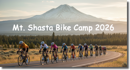
When: August 31st to September 4th Where: Mt. Shasta City, CA Cost: $25 per person (covers Happy Hour treats and any other bike camp expenses the club may incur)
What to Expect: Spectacular Routes: We will host two rides each day, a short route and a long route. Club Vibes: Share the road and the laughs with fellow club members. Whether you’re smashing out climbs or soaking up the miles, it’s all about enjoying the ride with your club members. Happy Hour: After the rides, enjoy happy hour snacks and drinks, plus group dinners, storytelling, and plenty of chances to relive the day’s highlights.
We counted every response (even the ones lobbying for permanent tailwinds). The results of the 2026 SFCC Member Survey are in! Thanks to everyone who participated and helped point the club toward an even better future.
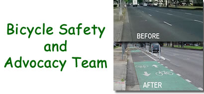
The SFCC does more than just ride around the foothills...we work to improve the riding safety and convenience for all riders in the area. Members of our club have formed a safety and advocacy team working with Placer County to improve the cycling infrastructure and ensure future development includes bicycle friendly features. Read more about our team's current projects and accomplishments and if you are interested in sharing your vision for a fun and safe cycling community.